Instituții și
Persoane implicate:
| Nume |
Prenume |
Rol |
Instituție |
| Matiş |
Anca |
participant |
Instiuție Nedefinită |
| Toderaş |
Meda |
participant |
Instiuție Nedefinită |
| Bleoancă |
Mihaela |
participant |
Instiuție Nedefinită |
| Jokhadze |
Saba |
participant |
Instiuție Nedefinită |
| Hansen |
Svend |
participant |
Deutsches Archäologisches Institut, Berlin, Germany |
| Anghel |
Dan |
participant |
Muzeul Naţional al Unirii, Alba Iulia |
| Burlacu-Timofte |
Raluca |
participant |
Muzeul Naţional al Unirii, Alba Iulia |
| Ciugudean |
Horia |
participant |
Muzeul Naţional al Unirii, Alba Iulia |
| Ciută |
Beatrice |
participant |
Muzeul Naţional al Unirii, Alba Iulia |
| Rustoiu |
Gabriel |
participant |
Muzeul Naţional al Unirii, Alba Iulia |
| Uhnér |
Claes |
participant |
Roemish-Germanischen Kommission, Germany |
| Kalmbach |
Johannes |
participant |
Roemish-Germanischen Kommission, Germany |
| Abuladze |
Joni |
participant |
Muzeul Național al Georgiei, , Tbilisi |
| Zhvania |
Dimitri |
participant |
Muzeul Național al Georgiei, , Tbilisi |
Raport:
Archaeological investigations of the Teleac hillfort started in 2016 as part of the LOEWE project “Prähistorische Konfliktforschung: Burgen der Bronzezeit zwischen Taunus und Karpaten” -nota 1. In 2017 the fieldwork consisted of (1) geomagnetic prospection inside and outside the settlement and (2) excavations inside the fortification.
Geomagnetic prospection. The Teleac hillfort was first surveyed during two campaigns in 2016 followed by a three week campaign in April 2017. The same methodology and five-channel SENSYS MAGNETO®-MX ARCH magnetometer with the sensors mounted in 50 cm distances were used in all three campaigns. Geo-referencing with a positional accuracy of ±0.02/±0.02m was achieved with a Leica DGPS system with the rover on the magnetometer. SENSYS MonMX, DLMGPS and MAGNETO® - ARCH was used for raw data processing and interpolation, whereas Oasis Montage 8 was used for post-processing. Analysis and data evaluation was made in QGIS 2.18.
The prospection in 2017 focussed on closing gaps on the magnetogram inside the hillfort and to extend the search area to the north of the settlement. The third objective was to investigate areas south of the fortification in search of outside habitation. The new areas surveyed are in line with the results of the surveys conducted in 2016. Intensive settlement activities are recorded on the magnetogram at almost all interior parts of the hillfort with flat or gently sloping terrain. The recorded anomalies are indicative of fire installations, concentrations of ceramics and daub, as well as pits and pit buildings found during excavation. A notable exception to the dense habitation is the almost empty magnetogram near the top of Jidovar Hill at the eastern part of the hillfort. As the excavations in the 1980ties documented up to 2 m deep cultural layers in the same area, it is likely that erosion from the steep top of the hill has covered this area with a thick layer of soil that the magnetometer do not penetrate. The new outside areas adjacent to the fortification surveyed in 2017 have no anomalies indicative of habitation and the same situation was encountered at the new area surveyed to the south of the hillfort. Most of the latter area is used for agriculture and most anomalies there have very high nanotesla values typical of metal scrap.
27 ha have been surveyed with a magnetometer since the start of the project. The main result of the prospection is a better understanding of the internal settlement structure. Overall, there is good correlation between excavated features and magnetic anomalies and it appears that the hillfort was densely occupied and spatially well organised with some areas reserved for different purposes. It is also evident that the absolute majority of the population lived inside the fortifications as all surveyed areas adjacent to the hillfort are essentially empty of anomalies indicative of occupation.
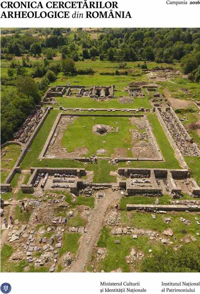
Excavations. The main focus of the 2017 excavations was to continue Trench 1 that was opened in 2016 at the northern part of the settlement and to start excavating Trench 5 next to the northern fortification system. In addition, Trench 6 and 7 were opened in the lower settlement. The locations of all trenches were based on data from the geophysical prospection.
Trench 1 (10x10 m). The excavations uncovered several fire installations concentrated to the southern half of the trench (Pl. 2/1, 6). The area measured 7x5 m and was oriented NNE-SSW and also contained several pits. In total 10 fire installations of various types were identified: FL16, A15, A16, A18, A21, A26 (Pl. 2/3), A28 (Pl. 2/4), A40, A45 and A37. At least two ovens had been repaired and reused. Interestingly, although these two features are of similar size and general construction, the northern one was built on a layer of pebbles, whereas the southern was built on a layer of ceramics - and both were rebuilt using the same materials (Pl. 2/5). The fire installations appear to belong to the same workshop, which extended from the southern part of the trench that has the oldest features towards the north where younger and better preserved features were found.
The pits all have circular outlines and convex profiles, apart from the bell shaped pit A41. Five pits were found outside the workshop. Of these, A 24 and A25 were found at the NW trench corner, whereas A29, A46 and A50 were located near the S trench wall. Several of the pits located close to the fire installations had ashy fill and were probably used to collect production waste from the workshop. Within the workshop, pit A30 and pit A31 were connected with a small channel (A47) to fire installation A26 (Pl. 2/5). Pits A35 and A43 were found adjacent to fire installation A26 and pit A41 was located together with hearth A45 (pl. 2/2). Pit A42 was found together with the two fire installations A33 and A36. It also appears that the workshop at one point was protected by a roof as area was traversed by a line of clay lined postholes (Pl. 2/7).
The stratigraphic sequence in Trench 1 consists of three general strata. The oldest comprise of the Gáva culture workshop for high temperature production and surrounding pits. The second have younger Gáva features and the youngest third consist of Basarabi culture features. The main find categories from trench 1 comprise of ceramic vessels (Pl. 2/8), clay figurines, as well as stone, bone and bronze implements.
Trench 5 (16x10 m) is oriented N-S and organized in quadrants of 2x2 m, numbered 1-8 from N to S and A-E from W to E. Two general strata were excavated in 2017. Both belong to the Gáva culture. The youngest was identified at a depth of 0.20-0.25 m in quadrants1-3/A-E and consists of a hearth (A2), and stones, burnt daub, ceramic sherds and animal bones in secondary positions (Pl. 3/1). They probably belong to a destroyed surface building which could not be outlined. Another hearth was found in quadrant 4D and seems to belong to a larger feature, possibly a sunken building. These features overlap a thick accumulation of debris from the destruction by fire of the rampart belonging to the fortification system (A28) and an adjacent surface building (A21) (Pl. 3/3). The cultural layers are formed of strata both of clayish consistence and loose ashy fill from the destruction of the rampart and palisade. This debris sealed the remains of the rampart and the adjacent surface building making both these features very well preserved. Building A21 measures 9x6 m and is oriented E – W. Most of the building is found within the trench and only part of the E wall extends outside the excavated surface. The building’s floor is not flat and varies in depth between 0.80 to 1.5 m probably due to compression underlying features. Two fire installations (A23 and A 24) were found just outside the NW corner of A21 (Pl. 3/2). The W part of the building was used as a storage area which contained several vessels with burnt seeds, two stone grinders and 30 large loom weights (A22) (Pl. 3/5). A well preserved wall section (A29), ca 120 x 150 cm was preserved on the floor of the building (Pl. 3/4). This find is quite informative from an architectural standpoint as it clearly shows how the wall was constructed by vertical sticks and small horizontal beams clad by daub. The building’s walls were built around two rows of stake holes with diameters between 0.10-0.15 m. A larger posthole (A32) for holding up the roof was located near a large oven (A30) in the E part of the building (Pl. 3/6). Among the materials found there are ceramic vessels, a large number of zoomorphic and anthropomorphic figurines, miniature wheels, sling shots and loom weights, bone pins, stone grinders and pestles, as well as metal implements made from bronze, iron and gold.
Only the upper parts of the inner fortification has been excavated thus far in quadrants 1/A-E, but it is already evident that it is a wooden framed box rampart (A28) which an upper wooden palisade. The S part of the trench, quadrants 5-8/A-E had very few features and seems to be a buffer zone between the fortification and the rest of the habitation at the Gruşet plateau.
Trench 6 (10x10 m) is located in the lower settlement (Pl. 4/1). 27 features of various types have been identified at this point. A1, A8 and A11 (Pl. 4/2) are buildings. A10, A12, A21 (Pl. 4/4) are pits (Pl. 4/4). A4, A5, A13, A18, A20, A22 and A27 are postholes (Pl. 4/5), whereas A6 and A9 are hearths. A1 is a sunken building, which was found at a depth of 0.5 m immediately under the plough soil. A1 has roundish elongated shape and the E side of the building had large amounts of daub from the walls. A 2.10 m x 0.50 m band of daub (A8) was found about 4 m north of the trench’s SE corner. The feature is oriented E to W and probably constitutes the remains from the N wall of a rectangular building that continues south of the trench (Pl. 4/6). The area south of this feature had three large bell-shaped pits. Part of a third building (A11) with large amounts of daub was found in the N part of the trench (Pl. 4/3). All the material in Trench 6 from 2017 is Gáva culture.
Trench 7 (5x6 m) (Pl. 4/7) is located directly S of Trench 6 with the aim of defining the southern extent of building A1 in Trench 6. Trench 7 was excavated down to a depth of about 1.10 m without finding much in terms of archaeological features apart from debris with large amounts of daub that seems to belong to feature A1 in Trench 6. Similar to Trench 6, the finds collected consist of ceramics, clay figurine fragments and loom weights, animal bones and a few metal objects.
99% of the ceramics found during the 2017 campaign belongs to the Gáva culture based on form and ornamentation. Basarabi ceramics make up the rest, usually found in secondary positions.
Objectives for the next campaign. The main aims for 2018 are to conduct additional geomagnetic prospection of areas outside the fortification system and investigate parts of the internal settlement by drilling. Excavations will continue of Trench 5, 6 and 7, and another aim is to collect more samples for C14 dating to build a Bayesian chronology for the site.
Rezumat:
Cercetările arheologice din anul 2017 în fortificaţia de la Teleac au continuat în cadrul proiectului LOEWE “Prähistorische Konfliktforschung: Burgen der Bronzezeit zwischen Taunus und Karpaten”. În luna aprilie au fost efectuate prospecţii geomagnetice atât în interiorul cât şi în exteriorul aşezării. Astfel, pe baza magnetogramei, au fost deschise suprafeţele T6 şi T7 pe platoul de jos al aşezării. A fost finalizată cercetarea în suprafaţa T1, în care au fost descoperite mai multe instalaţii de ardere: A21, A26, A28, A40, A45, A37 care, împreună cu cele descoperite în anul 2016 fac parte din aceeaşi structură. Totodată, au fost descoperite o serie de gropi: A24 şi A25 în colţul de NV al suprafeţei, A29, A46 şi A50 poziţionate în partea de sud a suprafeţei; A30, A31, A35, A43, A41 şi A42 identificate în jurul sau sub instalaţiile de foc. Suprafaţa T5 a fost deschisă între T1 şi sistemul de fortificaţie de pe latura de nord a aşezării. Au fost cercetate aici două niveluri aparţinând culturii Gáva: un nivel de locuire se află la adâncimea de 0,20-0,25 m, fiind marcat de vatra A2 şi mai multe materiale arheologice deranjate care provin de la o locuinţă de suprafaţă. O altă vatră (A12) marchează nivelul unei locuinţe adâncite de la acest prim nivel. Aceste complexe suprapun niveluri de distrugere care aparţin fortificaţiei de pe latura de N (A28), dar şi dintr-o construcţie amenajată lângă palisada sistemului de fortificaţie (A21). Construcţia, delimitată de şiruri de gropi de par, cu podea din lut, a fost incendiată odată cu palisada, mai multe vase ceramice cu seminţe carbonizate fiind descoperite lângă peretele de vest. Cele 27 de complexe identificate în T6 sunt de mai multe tipuri: structuri de locuire de diferite forme şi mărimi (A1, A8 şi A11), gropi (A10, A12 şi A21), gropi de stâlp (A4, A5, A13, A18, A20, A22 şi A27) şi vetre (A6 şi A9). În T7, nu au fost identificate complexe arheologice în această campanie. Materialul arheologic descoperit în 2017 constă din vase ceramice (întregi sau fragmentare), obiecte confecţionate din lut ars (figurine miniaturale zoomorfe şi antropomorfe, greutăţi, roţi de car miniatural, proiectile de praştie), obiecte din os (diferite tipuri de ace), piatră (râşniţe şi frecătoare) şi metal – bronz (ace, verigi, mărgele şi o fibulă), fier (câteva mici lame, probabil de la cuţite) şi aur (o verigă cu capetele desfăcute, decorată). Ceramica descoperită în această campanie, prin forme şi ornamente, aparţine culturii Gáva, în proporţie de cel puţin 99%. Mult mai rare sunt fragmentele tipice culturii Basarabi, multe aflate în poziţie secundară.