Bucşani | Judeţ: Giurgiu | Punct: La Şcoală | Anul: 2009
Descriere:
Anul cercetarii:
2009
Perioade:
Preistorie; Protoistorie; Evul Mediu;
Epoci:
Neolitic; Eneolitic; Epoca bronzului timpuriu; Epoca bronzului; Hallstatt; La Tène; Epoca migraţiilor; Epoca medievală timpurie; Epoca medievală timpurie; Evul Mediu;
Categorie:
Domestic; Religios, ritual şi funerar;
Tipuri de sit:
Tell; Necropolă;
Cod RAN:
| 101387.02 |
Județ:
Giurgiu
Unitate administrativă:
Bucşani
Localitate:
Bucşani
Punct:
La Şcoală
Localizare:
| 101387.02 |
Instituții și
Persoane implicate:
Persoane implicate:
| Nume | Prenume | Rol | Instituție |
|---|---|---|---|
| Popa | Traian | participant | Muzeul Judeţean de Istorie "Teohari Antonescu", Giurgiu |
| Bem | Carmen-Cornelia | participant | CIMEC - Institutul de Memorie Culturală, Bucureşti |
| Bem | Cătălin | participant | Muzeul Naţional de Istorie a României |
| Dumitraşcu | Emil | participant | Muzeul Naţional de Istorie a României |
| Dumitraşcu | Valentin | participant | Muzeul Naţional de Istorie a României |
| Florea | Mihai | participant | Muzeul Naţional de Istorie a României |
| Haită | Constantin | participant | Muzeul Naţional de Istorie a României |
| Nicolae | Cătălin | participant | Muzeul Naţional de Istorie a României |
| Oţa | Silviu Ion | participant | Muzeul Naţional de Istorie a României |
| Paraschiv | Eugen Dorel | participant | Muzeul Naţional de Istorie a României |
| Vasile | Sandu Gabriel | participant | Muzeul Naţional de Istorie a României |
| Vleja | Decebal | participant | Muzeul Naţional de Istorie a României |
| Asăndulesei | Andrei | participant | Universitatea "Alexandru Ioan Cuza", Iaşi |
Raport:
In the location of La Şcoală the first archaeological materials were discovered following surveys in 2004. Spatially, this toponym that underwent also the change described above included the spare ground in the close vicinity of the school building (built in the ’70s) and the private gardens enclosing it. At the time we had identified, at the surface of the soil (in the gardens mentioned), burned adobe bits and Gumelniţa pottery from the Bronze Age, the Laténe and from various phases of the mediaeval period. In 2007, the construction of an extension to the school building made it necessary to conduct a rescue excavation. The stratigraphical sequence of depositions in the area investigated in 2009 is the same one uncovered by the sections excavated in 2007,
We mention once more that most features were destroyed by the mediaeval cemetery that overlaps them stratigraphically. Therefore, the data on part of them is of mediocre quality.
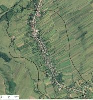
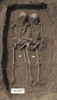
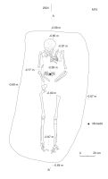
In the current stage of archaeological material processing, the mediaeval cemetery can be broadly dated, at first sight, to the 14th - 16th centuries. We partially or wholly investigated 311 graves. The triple graves (only one), the double ones or the reburials bring the number of the skeletons up to 323. 101 of these belonged to children (Infans I and Infans II), 28 to sub-adults (Juvenil), and 194 to adults - maturus and senilis (however, it is not out of the question for their number to decrease in favour of the second category - some of them were attributed on site, without the contribution of the anthropologist). In general, the grave pits are oval (especially in the case of the children) or rectangular, very seldom dug below the level of the lower terrace clay (that in general ends in the area of the cemetery at the maximum depth of 1.50 m). During the 2009 campaign we investigated less than half of the cemetery. The geomagnetic scanning provided us with the possibility of viewing the west and south limits. We came across the east limit within the excavated area, and the north one cannot be farther than about. 80 m to the north-west7 from the (north) limit of the same area. Thus, we may estimate the number of the graves at 7-800, that of the dead being higher, naturally. It is one of the largest village cemeteries in Wallachia. It began before the emergence of the princely authority, demonstrating both the intensity of the occupation, and the existence of a significant community here.


 CC BY-SA 4.0

